
Costa Rica / 1971 / DISPUTED
1971 Lake Cote Costa Rica UAP Photograph
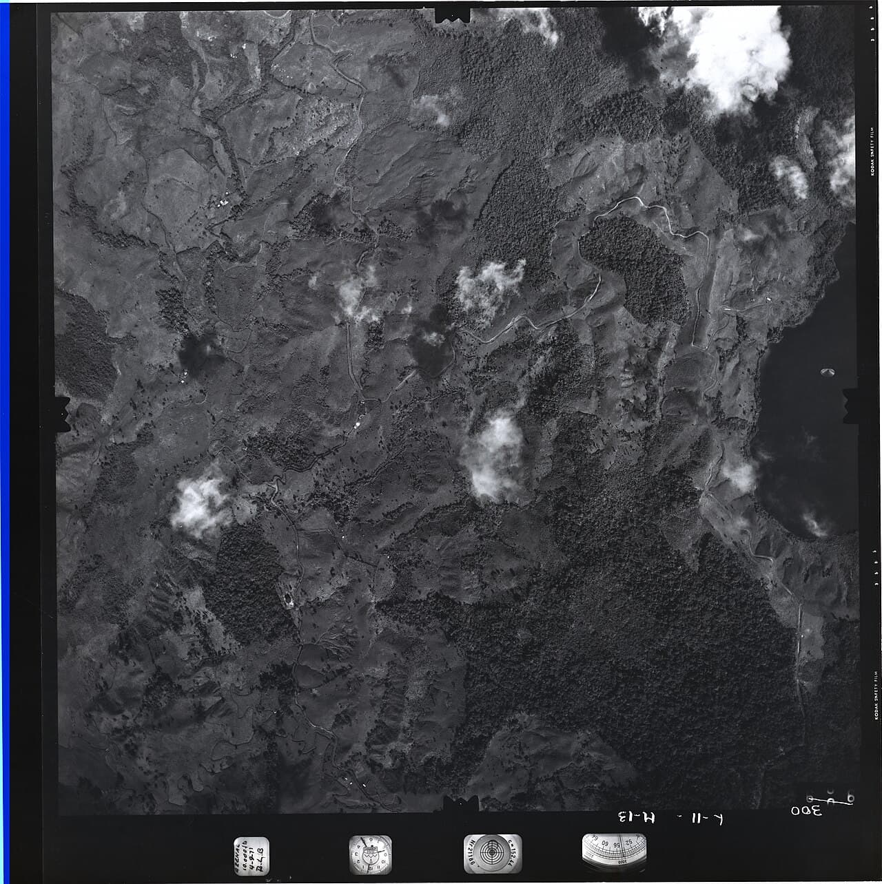
At 08:25 local time on 4 September 1971, an automated aerial-mapping camera recorded frame 300 over Lake Cote during a Costa Rican Instituto Geográfico Nacional survey flight. The four people aboard reported no unusual sight at the time. The frame contains a bright oval form against the lake; frames 299 and 301, exposed about twenty seconds before and after, do not. Richard Haines and Jacques Vallée first analyzed a second-generation negative, then reported examining the connected original-film frames in 1990. They rejected several processing and hoax mechanisms, while the referee to their 1989 paper argued that the image could be a pressure mark. Neither side established distance, scale, motion or physical identity. Costa Rica's National Archive now catalogs three related IGN images. The local display image is a later digital derivative of an 8-by-10-inch copy negative, not the original aerial negative. The photographic record is genuine; the oval form remains disputed.
This case is disputed. The archive preserves the claims while separating evidence from interpretation.
- Documentation
- High documentation
- Primary location
- Lake Cote, near the Alajuela-Guanacaste boundary
- Source base
- 6 linked records
- Research use
- Comparison case
What the Lake Cote record establishes
- Confirmed record
- Frame 300 was exposed at 08:25 local time on 4 September 1971 during an IGN aerial survey over Lake Cote.[1][2][4]
- Witness boundary
- The four people aboard did not report seeing the oval form during the flight; it was noticed in the photographic record.[2]
- Negative provenance
- The 1989 study used a second-generation negative; the 1990 follow-up reported direct inspection of connected original frames 299-301.[2][3]
Case dossier
The dated frame, not a visual encounter, is the event's secure starting point. Haines and Vallée reported that the government mapping aircraft was flying at a recorded altitude of 10,000 feet over Lake Cote. According to the information printed on the film, frame 300 carried the local time 08:25 and the date 4 September 1971. Their source described an R-M-K 15/23 mapping camera with a six-inch focal-length lens, 1/500-second exposure, f/5.6 aperture, ASA 80 black-and-white film and an intervalometer set near twenty seconds. These specifications come through later technical reporting, not a surviving flight log published by IGN.
Four people were aboard: an aerial-photography specialist, a pilot, a geographer and a topographer. The 1989 paper abbreviated their names, although later image metadata identifies the photographer as Sergio Loaiza. None reported seeing the oval form during the flight. Frame 300 shows it against the water near the lake edge; the adjacent frames do not. This establishes a photographic anomaly in one exposure, not a witnessed flight path. The absence from adjacent frames cannot yield a speed unless one first assumes a distant physical object moving through the photographed landscape.
The surviving analysis chain began years later. The 1989 paper says Costa Rican investigator Ricardo Vílchez interviewed the aerial-photography specialist in 1980. One author saw the photograph in Costa Rica in 1985 and obtained a second-generation negative; the team later received copies of frames 299 and 301. Their first paper measured the oval image at 4.2 millimetres on that copy. Its widely repeated 210-metre maximum length was conditional on placing the form at ground level, the full 10,000 feet from the camera. If it was nearer the camera—or was a film or optical artifact—its physical scale would be smaller or undefined.
Haines and Vallée found a sharp edge, a diffuse edge, internal brightness structure and no located ground shadow. They argued that the grain around the form did not show a simple double exposure. Their journal nevertheless printed a dissenting review by Lockheed scientist Marilyn E. Bruner. Based on the reproduced negative, she emphasized the unusually sharp boundary, inconsistent illumination and changing edge sharpness, and proposed a pressure mark made by a particle between film layers. She also stated that the original negative needed examination under glancing light. The published dispute is part of the evidence record, not a settled authentication.
On 11 February 1990, the authors reported receiving the connected original black-and-white frames 299 through 301. They said the film plane was flat, frame 300 had no developer stain, and scratches crossed the oval rather than stopping at its edge. On that basis they rejected a pressure depression, double exposure, reflection, paste-up and deliberate hoax, while leaving the form unidentified. Their follow-up also calculated high hypothetical speeds from the absent adjacent images. Those figures are not measurements: they require a ground-level object moving in a chosen straight line and exclude artifact, occlusion and nearer-object geometries by assumption.
The archive and the modern scan answer different questions. Costa Rica's National Archive catalogs record CR-AN-AH-FO-002544-1-002544-3 as three analog and digital IGN images created in 1971, describing the form as accidentally photographed at Lake Cote. That official description confirms custody and institutional context, not an extraordinary craft. The high-resolution scan later circulated online came from an 8-by-10-inch contact-copy negative. Wikimedia Commons records a 2025 upload, later orientation correction, scanning credit and Costa Rican public-domain rationale. Enlarging that derivative reveals more copy detail, scratches and processing history; it does not restore missing range, independent observation or original-film custody.
Timeline
- IGN survey frame 300 recorded the oval form over Lake Cote; the four people aboard reported no contemporaneous visual sighting.
- Ricardo Vílchez interviewed the aerial-photography specialist about the flight and image, according to the later technical paper.
- One of the later analysts saw the photograph in Costa Rica and obtained a second-generation negative for study.
- Haines and Vallée published their first analysis together with Bruner's dissenting pressure-mark review.
- The analysts reported receiving the connected original-film frames 299-301 for direct inspection.
- Costa Rica's National Archive uploaded digital access copies for its three-image IGN catalog record.
- Wikimedia Commons corrected the orientation of its modern drum-scan derivative and retained the Costa Rican public-domain label.
Lake Cote photograph questions
When was the Lake Cote photograph taken?
The film markings and later technical analysis identify frame 300 as exposed at 08:25 local time on 4 September 1971 during an IGN survey flight.
Did Sergio Loaiza or the crew see a UFO?
No contemporaneous visual sighting is documented. The four occupants reportedly saw nothing unusual during the flight; the case rests on what appeared in the photograph.
Is the public high-resolution image the original negative?
No. The public drum-scan lineage is an 8×10-inch contact-copy negative. The 1990 paper separately reported examining the connected original aerial-film frames.
How large was the object?
It is unknown. The often-cited 210-metre figure is a maximum calculated only if the image represents an object at ground level, 10,000 feet from the camera. No range was measured.
What is the leading conventional explanation?
The most developed published alternative is a pressure mark or related photographic artifact. Later original-film inspection argued against that exact mechanism, but no independently replicated test has resolved all film and optical possibilities.
Sources
- [1] Official fileCosta Rica National Archive catalog record CR-AN-AH-FO-002544-1-002544-3Archivo Nacional de Costa Rica
- [2] ResearchPhoto Analysis of an Aerial Disc Over Costa RicaJournal of Scientific Exploration / NICAP copy
- [3] ResearchPhoto Analysis of an Aerial Disc Over Costa Rica: New EvidenceJournal of Scientific Exploration / public PDF copy
- [4] ArchiveFull-frame Lake Cote drum-scan derivative and rights recordWikimedia Commons / Sergio Loaiza / IGN metadata
- [5] News reportThe Enticing Mysteries of U.F.O. PhotographyThe New Yorker
- [6] ResearchLake Cote camera, lighting and artifact discussionMetabunk
This is a later full-frame drum-scan derivative made from an 8×10-inch copy negative, not the original aerial-film negative. It is event-related photographic evidence because it reproduces frame 300, but later resolution and enlargement do not establish the oval form's distance, scale, motion or identity. Orientation and processing history must be considered in pixel-level analysis.