
Puerto Rico / 2013 / EXPLAINED
2013 Aguadilla UFO Video Incident
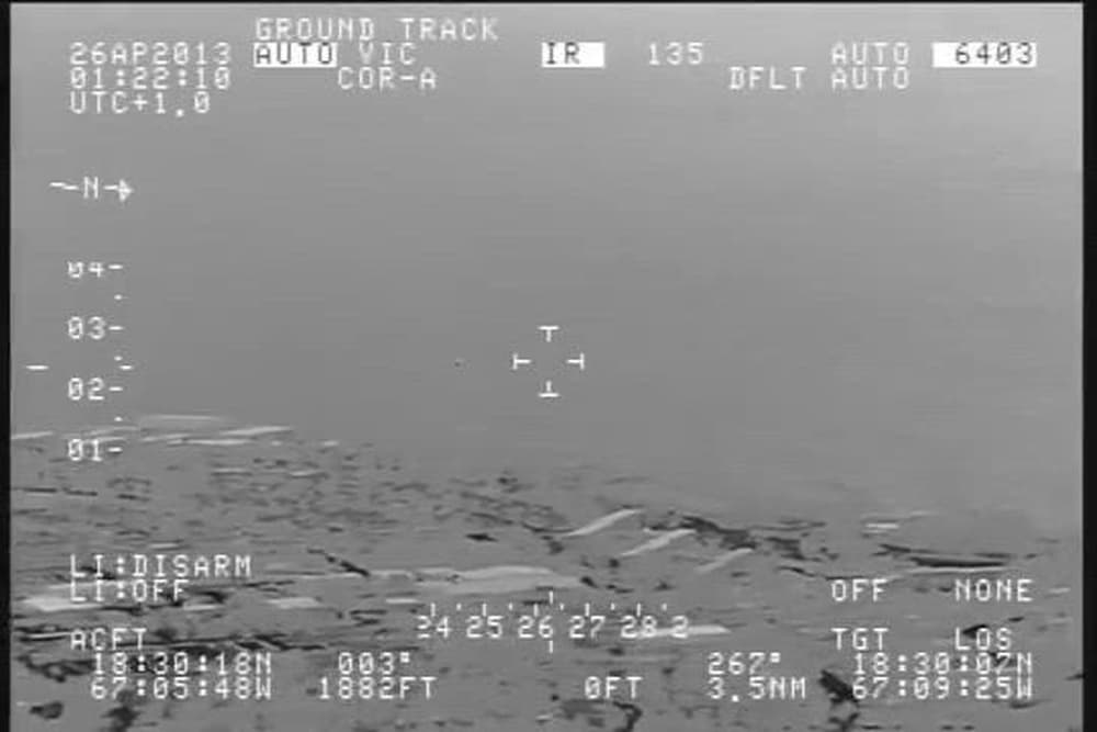
A U.S. Customs and Border Protection aircraft recorded 3 minutes 54 seconds of infrared video near Rafael Hernandez Airport in Aguadilla, Puerto Rico, during the night spanning 25-26 April 2013. An early independent study interpreted one target as fast, splitting and entering the ocean. AARO's 2025 reconstruction instead found two small objects drifting over land at about 8 mph: motion parallax created the apparent speed, changing view angle revealed their separation, and loss of thermal contrast made them seem to vanish at the waterline. AARO has high confidence that no anomalous or transmedium behavior occurred and moderate confidence that the objects were sky lanterns. The exact identity is not categorical, and the public sources disagree by one day on the local event date.
This archive treats the case as explained or substantially resolved by conventional evidence.
- Documentation
- High documentation
- Primary location
- Rafael Hernandez Airport, Aguadilla
- Source base
- 6 linked records
- Research use
- Comparison case
What the public record supports
- Confirmed record
- A CBP DHC-8 recorded an authentic 3:54 infrared sequence near Rafael Hernandez Airport.[1][3]
- Date conflict
- SCU uses 25 April local / 26 April UTC; AARO and DVIDS label the event 26 April.[1][3][5]
- Official finding
- AARO has high confidence there was no anomalous or transmedium performance and moderate confidence the objects were sky lanterns.[1][2][4]
AARO trajectory reconstruction
Case dossier
The underlying event is not a rumor or a recreated clip. An infrared sensor aboard a U.S. Customs and Border Protection De Havilland Canada 8 aircraft recorded small airborne targets while the aircraft climbed and circled Rafael Hernandez Airport near Aguadilla. DVIDS now hosts the official 3:54 file, and AARO has published both a case-resolution report and a digital reconstruction. Those records authenticate the video and its government origin; they do not, by themselves, make the targets extraordinary.
The date requires an explicit caution. The SCU report writes that the encounter began at 21:22 local time on 25 April 2013, corresponding to 01:22Z on 26 April, and the sensor overlay displays 26APR2013 with a UTC notation. AARO and DVIDS instead identify the event as 26 April and AARO describes 21:22 as local time on that date. No public acquisition log resolves whether the difference is a time-zone conversion or a later metadata error. This archive keeps 25 April as the local-date anchor while displaying both official versions.
The Scientific Coalition for UAP Studies published a detailed analysis in 2015 and later deposited version 2, together with the AVI file, on Zenodo. Its authors identified the sensor as a Wescam MX-15D and reconstructed a low, fast track. They argued that one object crossed the airport without a transponder, entered the Atlantic with little deceleration, emerged, enlarged and split. That report explains why the Aguadilla video became a leading transmedium claim, but these are the authors' analytic conclusions rather than findings issued by CBP, FAA or another government investigator.
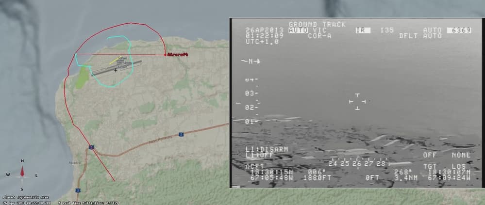
AARO presented a different reconstruction at a Senate hearing in November 2024 and issued a seven-page case resolution on 20 March 2025. It combined the aircraft's recorded position with sensor elevation, azimuth and slant-angle information in Systems Toolkit, then used line-of-sight and minimum-separation analysis. AARO assessed the targets at about 656 feet and smaller than one meter, while the observing aircraft climbed roughly 1,725 feet and the range to the targets nearly tripled. The report calls the target shapes indistinct and acknowledges that image quality worsened with distance and cloud cover.
In AARO's model, the two objects moved southwest in a straight line at approximately 3.6 metres per second, or 8 mph, close to the recorded east-northeast wind of 4.4 metres per second. The aircraft's own speed, circling path, sensor zoom and changing geometry produced motion parallax: slow nearby targets appeared to race across the background. The reconstructed line of sight placed the objects over land from first detection near the airport's northeast side until sensor contact ended above the central parking apron. This removes the need for extraordinary acceleration or an underwater trajectory.
The apparent split and water entry also have geometric and sensor explanations. AARO identified moments at about 29.56, 40.76 and 47.00 seconds when both objects were already separately visible. As the aircraft climbed, the view changed from shallow and side-on to steeper and more top-down, increasing their apparent separation. Near the end, the Atlantic formed part of the background while the small warm targets lost contrast. Thermal crossover, increasing range and scattered clouds could make their signatures fade, disappear and return without either target touching the water.
AARO attributes the objects to a pair of sky lanterns with moderate, not high, confidence. It cites their sub-one-metre estimated size, movement close to wind speed, variable flickering thermal signature and statements from local hospitality vendors that lantern releases are common at celebrations. The report considered marine birds unlikely because wings or wingbeat pulsation should have remained visible at the modeled distances. It also discussed tied Mylar balloons but rejected reflected moonlight as the proposed infrared mechanism. Poor video quality prevents a categorical identification.
SCU did not accept the public resolution without further data. In April 2025 it said AARO had acknowledged questions about the three-dimensional coordinates, uncertainty margins, cloud-layer source, tower or military radar records and the pixel analysis used to reject a utility-pole crossing, but had not yet supplied answers. These are legitimate reproducibility questions. They limit independent verification of the model, yet they do not restore evidence of high speed or water entry. The current record most strongly supports two slow windborne objects whose extraordinary appearance arose from geometry and thermal imaging; exact sky-lantern identification remains probable rather than proven.
AARO's digital reconstruction
The official reconstruction shows the modeled aircraft path, sensor line of sight and two-object trajectory over land. It is an explanatory visualization created after the event, not original footage.
Related video
Timeline
- SCU dates the start to 21:22 local on 25 April, or 01:22Z on 26 April; AARO and DVIDS identify the event as 26 April.
- A CBP DHC-8 records the 3:54 infrared sequence while climbing and circling near Rafael Hernandez Airport.
- SCU publishes version 2 of its detailed report, interpreting high speed, water entry and splitting.
- Zenodo creates the open record containing the SCU report and the AVI video file.
- AARO presents the over-land, wind-speed reconstruction to the U.S. Senate; DVIDS posts the official event video.
- AARO issues its case resolution: high confidence of no anomalous behavior and moderate confidence in two sky lanterns.
- SCU publishes five methodological questions and says AARO has acknowledged but not yet answered them.
Frequently asked questions
What does the Aguadilla UFO video show?
It shows small infrared targets tracked from a moving CBP aircraft near Rafael Hernandez Airport. The objects appear fast, separate and fade near an ocean background, but the video alone does not establish range or identity.
When was the Aguadilla video recorded?
SCU states 21:22 local on 25 April 2013, corresponding to 01:22Z on 26 April. AARO and DVIDS label the event 26 April. The public record does not reconcile the discrepancy.
Did the object split into two?
AARO found two objects visible separately several times within the first minute. The changing view angle later made their separation more obvious; it did not show one object physically dividing.
Did the Aguadilla objects enter the ocean?
AARO's reconstructed line of sight keeps them over land. Their signatures faded as the ocean became background, consistent with thermal crossover, greater range and clouds rather than water entry.
What did AARO conclude?
AARO concluded with high confidence that the targets showed no anomalous speed or transmedium behavior, and with moderate confidence that they were a pair of sky lanterns.
Why does AARO favor sky lanterns?
The estimated size, wind-speed drift, variable weakening heat signature and local reports of celebration releases fit sky lanterns. Image quality is too poor for a categorical visual identification.
Does the video prove extraterrestrial technology?
No. The video is authentic, but AARO's reconstruction explains the apparent extraordinary behavior without exotic technology. The exact objects are not categorically identified.
Sources
- [1] Official fileAARO case resolution: The Puerto Rico ObjectAll-domain Anomaly Resolution Office
- [2] Official fileAARO Senate hearing case slidesAll-domain Anomaly Resolution Office
- [3] Official filePuerto Rico Objects: official infrared videoDefense Media Activity / DVIDS
- [4] Official file2013 Puerto Rico Object ReconstructionDefense Media Activity / DVIDS
- [5] Research2013 Aguadilla Puerto Rico UAP: detailed analysisScientific Coalition for UAP Studies / Zenodo
- [6] ResearchSCU response to the AARO Aguadilla investigationScientific Coalition for UAP Studies
The main image is a frame from the official CBP infrared video released by DVIDS. It documents the recorded sensor view but does not by itself establish range, speed, water entry or identity. The supplementary image is AARO's later analytic reconstruction, not another event camera angle.